|
Discover America, the national US tourism team, has created a website at www.visittheUSA.com that has enough bells and whistles to tempt any Canadian with wanderlust to venture south of the border.
One of the most compelling sections on their website is simply titled: “Road Trips”… But beware! For here you will find details on all those great American Road Trips that you always dreamt you would take one day…
|
|
From the Blues Highway to Route 66... from The Great River Road to the Pacific Coast Highway... take your choice and experience the USA on the road on an epic journey of your own making!
National Parks of the Western USA Road Trip
Chris selected this road trip to celebrate the 100th anniversary of the National Parks Service. His itinerary takes in some of the oldest and most iconic National Parks and Monuments in America and together they provide a stunning geology lesson. From awe inspiring redwood and sequoia trees to the magnificence of the Grand Canyon, the fearsome deserts of Death Valley, the astonishing petrified forest and the stunning caves deep underground at Carlsbad Caverns – you cannot fail to be humbled by Nature’s grandeur
This is the U.S. National Park Service is celebrating one hundred years of preserving, protecting and opening up some of the greatest natural and historical spaces on the continent. Starting in the Nineteenth Century, the scenic natural wonders of the West, such as the towering mountains and majestic trees of Yosemite and the immense vistas of the Grand Canyon, inspired individual Americans to call for their preservation, asking their government to create something called “National Parks.”
In 1916, the work of caring for these places was moved to a new agency created by Congress for that specific purpose. The National Park Service was given the responsibility to not only conserve and protect parks, but also to leave them “unimpaired for the enjoyment of future generations.”
Today there are over 400 national parks and monuments which include not only places of scenic grandeur, but also places that commemorate history too. The National Parks have been described as “America’s Best Idea”. This trip will make that claim come alive in the region where the idea was first realized: America’s West. There is also lots more info on the National Parks specifically at outdoors.visittheUSA.ca.
Look out for a dazzling visual celebration of the USA’s majestic National Parks on IMAX film. It’s called “America Wild: National Parks Adventure” and it takes us off on the ultimate off-trail adventure into America’s awe-inspiring great outdoors and untamed wilderness. Yosemite is one of the stars in this breath-taking film which celebrates the nation’s Centennial Anniversary of the U.S. National Parks. Don’t miss it: it will inspire you to come see some of the places Chris is visiting on his Great American Road Trip.
Travel Tips:
This year many of the National Parks have put together special events and programming to celebrate their 100th birthday. Check out www.nps.gov
Purchase America the Beautiful Annual Pass for $80 USD at any National Park or Monument Visitor Center. It’s a great deal if you are visiting several of the parks.
 From the glorious Sequoia trees of Sequoia National Park to historic graffiti in El Morro National Monument. From the towering heights of the Grand Canyon to desert lying below sea level in Death Valley. From wood tuned to stone in Petrified Wood National Monument to lava flows in El Malpais National Monument. And from the soaring granite peaks of Yosemite National Park to the caves deep underground in Carlsbad Caverns. Each represents a unique adventure through geology, history and nature and a humbling opportunity to visit some of the most stunning landscapes in America. Here are the highlight’s of Chris’ road trip.
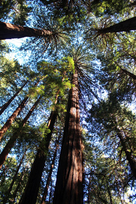
Muir Woods - A Tree Lover's Monument
When John Muir learned that William and Elizabeth Kent were naming a redwood forest near San Francisco in his honor, he declared, "This is the best tree-lovers monument that could possibly be found in all the forests of the world." The couple had purchased the land to preserve its beauty and restful wilderness; and in 1908, they donated it to the federal government to protect it from destruction.
Presidio of San Francisco – Experience a Diversity of Natural and Cultural History
For 218 years, the Presidio served as an army post for three nations. World and local events, from military campaigns to World Fairs and earthquakes, left their mark. Come enjoy the history and the natural beauty of the Presidio. Explore centuries of architecture. Reflect in a national cemetery. Walk along an historic airfield, through forests or to beaches, and admire spectacular vistas.
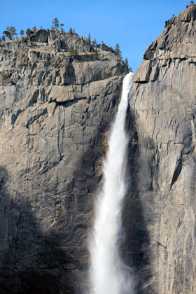
Yosemite – Grandeur in Granite
Not just a great valley, but a shrine to human foresight, the strength of granite, the power of glaciers, the persistence of life, and the tranquility of the High Sierra.
First protected in 1864, Yosemite National Park is best known for its waterfalls, but within its nearly 1,200 square miles, you can find deep valleys, grand meadows, ancient giant sequoias, a vast wilderness area, and much more.
Sequoia & Kings Canyon - A Land of Giants
This dramatic landscape testifies to nature's size, beauty, and diversity--huge mountains, rugged foothills, deep canyons, vast caverns, and the world's largest trees. These two parks lie side by side in the southern Sierra Nevada east of the San Joaquin Valley. Weather varies a lot by season and elevation, which ranges from 1,370' to 14,494'. Sequoias grow at 5,000 - 7,000', above usual snowline.
Death Valley - Hottest, Driest, Lowest!
In this below-sea-level basin, steady drought and record summer heat make Death Valley a land of extremes. Yet, each extreme has a striking contrast. Towering peaks are frosted with winter snow. Rare rainstorms bring vast fields of wildflowers. Lush oases harbor tiny fish and refuge for wildlife and humans. Despite its morbid name, a great diversity of life survives in Death Valley.
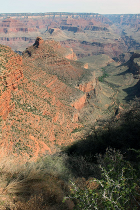
Grand Canyon – Every step down is 10,000 yrs of history
Unique combinations of geologic color and erosional forms decorate a canyon that is 277 river miles (446km) long, up to 18 miles (29km) wide, and a mile (1.6km) deep. Grand Canyon overwhelms our senses through its immense size
Petrified Forest - A Place for Discovery
Did you know that Petrified Forest is more spectacular than ever? While the park has all the wonders known for a century, there are many new adventures and discoveries to share. There are backcountry hikes into areas never open before such as Red Basin and little known areas like the Martha's Butte. There are new exhibits to bring the stories to life. Come rediscover Petrified Forest!
El Morro - Paso por aqui...
Imagine the comfort and refreshment of finding water after days of dusty travel. A reliable waterhole hidden at the base of a sandstone bluff made El Morro (the headland) a popular campsite for hundreds of years. Here, Ancestral Puebloans, Spanish and American travelers carved over 2,000 signatures, dates, messages, and petroglyphs. We invite you to make El Morro a stopping point on your travels.
El Malpais - Rivers of Ancient Fires
The richly diverse volcanic landscape of El Malpais offers solitude, recreation, and discovery. Explore cinder cones, lava tube caves, sandstone bluffs, and hiking trails. Wildlife abounds in the open grasslands and forests. While some may see a desolate environment, people have been adapting to and living in this extraordinary terrain for generations. Come discover the land of fire and ice!
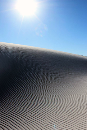
White Sands - Like No Place Else on Earth
Rising from the heart of the Tularosa Basin is one of the world's great natural wonders - the glistening white sands of New Mexico. Great wave-like dunes of gypsum sand have engulfed 275 square miles of desert, creating the world's largest gypsum dunefield. White Sands National Monument preserves a major portion of this unique dunefield, along with the plants and animals that live here.
Carlsbad Caverns - Beauty and Wonder; Above and Below
High ancient sea ledges, deep rocky canyons, flowering cactus and desert wildlife - treasures above the ground in the Chihuahuan Desert. Hidden beneath the surface are more than 119 known caves - all formed when sulfuric acid dissolved the surrounding limestone leaving behind caverns of all sizes.
 Here is Chris’ National Park itinerary through California.
Flew from Toronto to San Francisco Airport and picked up a rental car.
Muir Woods National Monument. (Get on US-101 from Funston Ave and Girard Rd 3 min (0.8 mi); Follow US-101 to CA-1 N in Marin County. Take exit 445B from US-101 9 min (7.1 mi); Follow CA-1 N, Panoramic Hwy and Muir Woods Rd to your destination 16 min (5.8 mi) Total 30 mins, 15 miles)
- Muir Woods National Monument
- Visitor Centre
- Hike amongst the redwoods
- Drive Muir Woods Road to Pacific Ocean, returning on Panoramic Highway and over Golden Gate Bridge
- The Presidio National Park
- Dinner in Fishermans’ Wharf and Cable Car ride in San Francisco
Overnight: The Inn at Presidio 42 Moraga Ave, San Francisco, CA 94129 Phone: 415-800-7356. Free WiFi available in room.
San Francisco to Yosemite National Park
4 hours, 193 miles (Take Presidio Blvd, Lyon St, Bush St and Gough St to US-101 17 min (3.8 mi); Take I-580 E, I-205 E and CA-99 S to CA-140 E/Yosemite Pkwy in Merced. Take exit 186B from CA-99 S, 2 h 4 min (131 mi) At Merced, Follow CA-140 E to Foresta Rd in Mariposa County, 1 h 23 min (64.6 mi)
- 2 days to enjoy the sights and hiking trails of Yosemite National Park.
- Tunnel View provides one of the most famous views of Yosemite Valley. From here you can see El Capitan and Bridalveil Fall rising from Yosemite Valley, with Half Dome in the background.
- Half Dome is perhaps the most recognized symbol of Yosemite. Rising nearly 5,000 feet above the Valley floor, it is one of the most sought-after landmarks in Yosemite. Some people even hike or rock-climb to the top. You can see Half Dome throughout much of eastern Yosemite Valley, including on the road between Yosemite Village and Yosemite Valley Lodge (formerly Yosemite Lodge) and roads near Half Dome Village (formerly Curry Village). Mirror Lake, while not really a lake, is a popular place to see Half Dome from up close.
- El Capitan, rising over 3,000 feet above the floor of Yosemite Valley, is a favorite for experienced rock climbers. El Capitan is opposite Bridalveil Fall and is best seen from the roads in western Yosemite Valley, including Tunnel View, Bridalveil Fall area, and El Capitan Meadow.
- Valley Visitor Center: Ranger-staffed information desk, bookstore, Spirit of Yosemite film, and exhibits detailing the park's geology, animal life, and history.
- Yosemite Museum: The Indian Cultural Exhibit and Village interpret the cultural history of Yosemite's native Miwok and Paiute people from 1850 to the present. Demonstrations of traditional skills are presented. The Gallery offers art exhibits throughout the year.
- Hikes: Bridalveil Falls (20m); Mirror Lake (20m); Lower Yosemite Fall (30m)
2 nights: Yosemite View Lodge, 11156 Hwy 140, El Portal, CA 95318, Phone 209 379-2681 yosemiteviewlodge@yosemiteresorts.net . WiFi available at a cost. Hotel is 2 miles outside Park gate
Yosemite to Sequoia and Kings Canyon
4.5 hours 200 miles (Take 140 S to CA-49 (30 miles) then CA-49 to CA-$41 South at Oakhurst to Fresno turn S onto CA-99 then E on CA-198 at Goshen, bypassing Visalia, all the way to Ash Mountain Entrance). Continue 22 miles into Park on CA-198.
- Sequoia National Park and neighbouring Kings Canyon National Park
- Giant Forest Museum
- Giant Forest hike
Overnight: Wuksachi Lodge, Wuksachi Way, Sequoia National Park, CA, Tel (866) 807-3598. Free WiFi available in room.
Sequoia to Death Valley
6.5 hours, 343 miles. Generals Highway from Lodgepole to Grant Grove and exit park. Continue on CA-198 W. Take CA-65 S, CA-58 E and CA-14 N/Midland Trail to Redrock Randsburg Rd in Kern County 3 h 58 min (193 mi); Continue on Redrock Randsburg Rd to US-395 N 21 min (20.5 mi); Turn left onto US-395 N 3 min (3.1 mi); Follow Trona Rd, Trona Wildrose Rd and Panamint Valley Rd to CA-190 E in Inyo County 1 h 18 min (74.2 mi); Turn right onto CA-190 E (signs for Furnace Creek 53) 56 min (52.3 mi)
- Death Valley National Park
- Father Crawley viewpoint
- Mesquite Flats Sand Dunes
- Badwater (lowest place in North America), return north, taking
- Artist Drive
- Zabriskie Point (good place for sunset)
Take CA-190 east to exit the park.Drive to Pahrump, Nevada: 61 miles, 1 hour Turn right onto CA-190 E 30.1 mi; Turn right onto CA-127 S, 0.2 mi; Turn left onto State Line Rd 3.5 mi; Continue onto Bell Vista Rd; Entering Nevada 22.3 mi; Turn right onto NV-160 E;
Overnight: Best Western Pahrump Oasis, 1101 S Highway 160, Pahrump, Nevada, 89048-4700, US Phone: 775/727-5100. Free WiFi available in room.
 Here is Chris’ National Park itinerary through Arizona.
Death Valley to Grand Canyon
hours, 320 miles. (Get on I-215 E in Enterprise from NV-160 W 56 min (53.6 mi); bypass Vegas; Follow US-93 S through Henderson and Hoover Dam to Kingman and I-40 E to AZ-64 N/Historic Rte 66 in Williams. Take exit 165 from I-40 E 3 h 11 min (216 mi); Turn left onto AZ-64 N/Historic Rte 66 Continue to follow AZ-64 N 46 min (49.8 mi); At the traffic circle, take the 1st exit onto US-180 N 11 s (417 ft) Drive to hotel 1 min (423 ft)
- Grand Canyon National Park
- Grand Canyon Visitor Center
- Bright Angel Trail
- South Kaibab Trail
- Rim Trail
- Hopi Point
- Grandview Point
- Desert View
- Tusayan Museum Ruin and Museum
- Watchtower
2 nights: Grand Canyon Squire Inn, 74 Highway 64, Tusayan, AZ 86023 Phone: 928-638-2681 Free WiFi available in room.
Grand Canyon to Petrified Forest
2.5 hours, 170 miles. (Head south on US-180 S; At the traffic circle, take the 2nd exit and stay on US-180 S 21.9 mi; Continue straight onto AZ-64 S 27.9 mi; Turn left to merge onto I-40 E 119 mi; Take exit 285 for I-40/US-180 E toward AZ-77 S/Petrified Forest Nat Park 0.3 mi; Turn right onto US-180 E/W Hopi Dr
- Meteor Crater exit 233 6 miles south between Winslow and Winona – best preserved meteor impact crater on the planet. Admission price includes 3 lookout points on the rim of the crater, telescopes on the viewing platforms, guided rim tour (weather permitting), an Interactive Discovery Center, theater showing the movie “IMPACT” twice per hour, as well as a guided tour on the rim of the crater. There are three different lookout points to view the crater. Visitors should try to allow 1 1/2 hours to go through the Discovery Center and lookouts and additional time for our guided rim trail tour, which will take an additional 45 minutes to an hour.
- Winslow – immortalized in popular culture by the Eagle’s song “Take it Easy”
- Petrified Forest National Park
- Painted Desert
- Rainbow Forest Museum
- Blue Mesa
- Crystal Forest
Overnight: The Wigwam Motel 811 W Hopi Dr, Holbrook, AZ 86025 Tel: 928-524-3048 Fax: 928-524-3668. Free WiFi available in room. Built in the late 1940s along Historic Route 66, this unique motel includes 15 individual units constructed to look like teepees. Rooms are non-smoking and include restrooms with showers, but no telephones. There is a small museum of Indian artifacts, Historic Route 66 artifacts and Civil War artifacts on property.
 Here is Chris’ National Park itinerary through New Mexico.
Petrified Forest via El Moro and El Malpais to Albuquerque
5 hours, 211 miles. (Take Interstate 40 east to Gallup. At exit 20, go south on Highway 602 for about 31 miles. Turn east (left) onto Highway 53. El Morro is 25 more miles. If you’d like to drive through Zuni from the west, take exit 339 from Interstate 40 in AZ, and go south on Highway 191 for 24 miles. Take Highway 61/53 into Zuni. El Morro is about 36 miles from Zuni).
- El Morro National Monument
- Hike Mesa Top Trail
- Visit Inscription Rock
Drive to El Malpais: 60 miles, 1 hour. (Turn right onto NM-53 E 40.6 mi Use the right lane to take the ramp onto I-40 E 7.2 mi; Take exit 89 toward Quemado 0.3 mi; Turn right onto NM-117 E El Malpais Ranger Station will be on the left after 8.9 mi)
- El Malpais National Monument
- Sandstone Bluffs Overlook
- Zuni Acoma Trail
Drive to Albuquerque 1hr 15 mins, 84 miles. (Get on I-40 E 10 min (9.2 mi); Follow I-40 E to Pan American Frontage Rd N in Albuquerque. Take exit 230 from I-25 N 1 h 2 min (73.5 mi); Continue on Pan American Frontage Rd N to hotel 2 min (0.4 mi)
Overnight: Nativo Lodge, Albuquerque, 6000 Pan American Freeway 87109 505-7987-4300. Free WiFi available in room.
Albuquerque to White Sands National Monument
4 hours, 226 miles. (Drive to White Sands: 3.5 hours, 230 miles: Get on I-25 S from San Mateo Blvd NE, 3 min (0.7 mi); Follow I-25 S to San Antonio, US-380 E to Carrizozo and US-54 W to Alomorgordo and I-70 to Dunes Dr in Otero County, 3 h 24 min (229 mi); Turn right onto Dunes Dr; Destination will be on the left 1 min (0.3 mi)
- White Sands National Monument
- Heart of the Sands
- Interdune Boardwalk
- Rent a sled and slide down the dunes!
Depart White Sands to drive to hotel: 60 miles, 1 hour: Head southeast on Dunes Dr toward Residence Cir1 min (0.3 mi); Continue on US-70 E to Carrizo Canyon Rd/Indn Service Rte 4 1 h 3 min (56.3 mi); Follow Carrizo Canyon Rd/Indn Service Rte 4 to hotel 6 min (3.2 mi)
Overnight in Mescalero: Inn of the Mountain Gods: 287 Carrizo Canyon Road 88340 575-464-7780. Free WiFi available in room.
White Sands to Carlsbad Caverns
3.5 hours, 181 miles. (3hrs 15 mins 178 miles: Follow Carrizo Canyon Rd and Sudderth Dr to US-70 E/Billy the Kid Trail in Ruidoso 11 min (5.3 mi); Follow US-70 E to Hondo; US-380 to Roswell and US-285 S to Carlsbad; NM-524 E in Eddy County 2 h 13 min (138 mi); Continue on NM-524 E to Carlsbad 17 min (11.5 mi); Turn right onto US-180 W/US-62 W 14 min (15.7 mi) to Whites City; Turn right onto NM-7 W Destination will be on the left 13 min (7.3 mi)).
- Carlsbad Caverns National Park
- Walnut Canyon Desert Drive
- North Slaughter Canyon Trail
- Bat flight in seasaon at sunset
Depart for hotel: 27 miles, 35 mins Head west on NM-7 E 7.3 mi; Turn left onto US-180 E/US-62 E 20.0 mi; Turn left onto W Greene St 266 ft; Turn right at the 1st cross street toward W Fox St 430 ft; Turn right at the 1st cross street onto W Fox St 177 ft; Turn right at the 1st cross street onto S Canal St; Hotel will be on the right 66 ft
Overnight in Carlsbad: Trinity Hotel, South Canal St. Carlsbad, New Mexico. 575-234-9891. Free WiFi available in room.
Carlsbad to Santa Fe
4 hours, 273 miles. (Leave for Santa Fe: Follow US-285 N to Relief Route in Chaves County 1 h 10 min (71.6 mi); Turn left onto Relief Route 18 min (15.3 mi); Follow US-285 N to NM-466 N/Old Pecos Trail in Santa Fe County. Take exit 284 from I-25 S/US-285 N 2 h 39 min (182 mi); Follow Old Pecos Trail and Old Santa Fe Trail to E San Francisco St in Santa Fe)
After 1 hr 20 mins, 76 miles, stop at Roswell New Mexico, centre of the “1947 Roswell Incident” and of global UFOlogy
Continue to Santa Fe, capital of New Mexico and second oldest city in North America.
- Palace of the Governors
- Cathedral of St. Francis
- Georgia O’Keeffe Museum
Drive south to Albuquerque
1 hour, 64 miles. Get on I-25 S from Old Santa Fe Trail and Old Pecos Trail 11 min (4.0 mi); Follow I-25 S to Carlisle Blvd NE in Albuquerque. Take exit 160 from I-40 E 50 min (59.3 mi); Continue on Carlisle Blvd NE. Drive to Amherst Dr NE.
Old Town
San Felipe de Neri Church
Church St Café for farewell dinner
Overnight in Albuquerque at Hotel Albuquerque, 800 Rio Grande Blvd. NW 87104 505-843-6300 . Free WiFi available in room.
Albuquerque Airport to Toronto
10 mins, 7 miles. (Get on I-40 E 2 min (0.6 mi); Head west on Pueblo Bonito Ct NW toward Rio Grande Blvd NW 108 ft; Turn right at the 1st cross street onto Rio Grande Blvd NW 0.3 mi; Turn right to merge onto I-40 E 0.2 mi; Continue on I-40 E. Take I-25 S to Sunport Blvd. Take exit 221 from I-25 S 6 min (6.0 mi); Use any lane to turn left onto Sunport Blvd 1 min (0.8 mi)).
Albuquerque International Sunport, 2200 Sunport Blvd, Albuquerque, NM 87106
Rental car drop off and fly back to Toronto
Want to know more about the destination? Check out Chris' Travel Notes!
Chris writes extensive Travel Notes for each show that will help you plan your next trip. Find out more about the Destination; Climate; Getting Around; Accommodation; Kids to Seniors; History; Sports and Activities; Attractions; Culture; Cuisine; Special Deals and where to go to get even more information!
Click on the Travel Notes icon to download a pdf file that you can read, print out and even take with you on your travels! |
|